|
|
|
Boulia in Queensland
A tourist selfdrive tourist guide and information
|
|
|
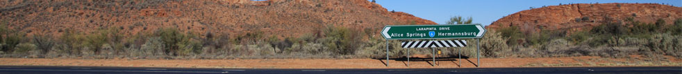
Alice Springs
 Then
on to Boulia Then
on to Boulia
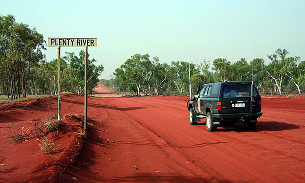
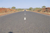
The link between Central Australia and Outback Queensland
is provided by the Plenty and Donohue Highways. This
stretch of road was first built to allow cattle stations
a means of transporting beef through road train access.
Today, it is also a 'short-cut' for travellers from
Boulia, Mt.Isa and other outback Queensland towns to
get to Alice Springs and the'Red Centre' in a more direct
way.
The Plenty/Donohue highways are a
long pathway through open plains, cattle stations and
aboriginal communities.
Several rivers and creeks which form the channel country
need to be crossed through this diversity of country
from red sand and clay to bulldust and gravel.
|
|
|
Boulia
 The
town of Boulia is the pivotal point of the far west,
with Mount Isa 300 kilometres to the north and Winton
370 kilometres to the east. It is linked to Alice Springs
via the Donohue Highway and the town is acknowledged
as being the Capital of the Channel Country, which gives
rise to the great rivers that flow west to Lake Eyre. The
town of Boulia is the pivotal point of the far west,
with Mount Isa 300 kilometres to the north and Winton
370 kilometres to the east. It is linked to Alice Springs
via the Donohue Highway and the town is acknowledged
as being the Capital of the Channel Country, which gives
rise to the great rivers that flow west to Lake Eyre.
Boulia is the centre of a prosperous beef and wool
industry with cattle generally grazed in the western
and northern areas and sheep properties to the east.
The Shire shares a 320 kilometre common border with
the Northern Territory and it's western boundary marks
the eastern edge of the mighty Simpson Desert.
|
|
|
Camel racing in Boulia at the Boulia Camel
Races.
 This
event is held annually on the third weekend of July
each year. It's an event not to be missed, as the ships
of the desert show their paces around the race track,
hopefully the right way around. Free camping at the
Racecourse is included in the entry fee for the weekend.
A range of accommodation is available in the Boulia
Shire including a Motel, Hotel/Motel, Caravan Park and
Station Stay. Great dining is to be had, whether it
be at the Hotel/Motels Cooridgea Watering Hole and
Restaurant, the Choice Roadhouse or the Encounters Café. This
event is held annually on the third weekend of July
each year. It's an event not to be missed, as the ships
of the desert show their paces around the race track,
hopefully the right way around. Free camping at the
Racecourse is included in the entry fee for the weekend.
A range of accommodation is available in the Boulia
Shire including a Motel, Hotel/Motel, Caravan Park and
Station Stay. Great dining is to be had, whether it
be at the Hotel/Motels Cooridgea Watering Hole and
Restaurant, the Choice Roadhouse or the Encounters Café.
Town
information at http://www.boulia.qld.gov.au/
|
|
|
 How
to get here. How
to get here.
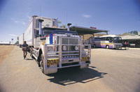
We have sealed
roads linking Boulia to Winton (Kennedy Developmental
Road) and also Mount Isa (Diamantina Developmental Road).
The Diamantina Developmental Road from Boulia to Bedourie
is partially sealed. Boulia can also lay claim to having
a short cut gravel road taking travellers across to
Alice Springs (Donohue and Plenty highways).
|
|
|
About The Outback Way
The Outback Way extends 2,750km from Laverton, Western
Australia to Winton, Queensland via central Australia.
As a self-drive route it passes through central Australias
deserts, Ayers Rock, The Olgas, Alice Springs and a
host of fascinating places of interest. The Outback
Way is made up of seven inter-connecting roads including
The Great Central Road (WA); Tjukaruru Road, Lasseter
Highway, Stuart Highway and Plenty Highway (NT); and
Donohue Highway and Min Min Byway (QLD). Collectively
these are
THE OUTBACK WAY
There are very few road signs in outback Australia
and many of the Outback Ways places of interest are
sometimes not so easy to find. Then again, it wouldnt
be an outback adventure without an element of surprise!
The adventurous traveller has plenty to discover, and
the less adventurous traveller can safely prepare their
outback journey using this website, the brochure and
the Guidebook!
When to travel the Outback Way
http://www.outbackway.org.au/
|
 |
|
|
|
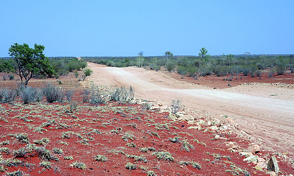
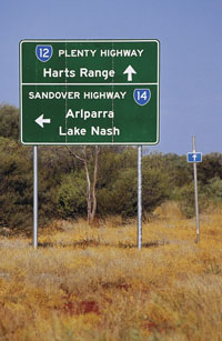
The Plenty Highway accurately doesn't commence till
around the NT/QLD border, to get there you travel from
Boulia in outback Queensland along the Donohue Highway
(track). Typically spoken , the Queensland section of
the track is in the worst condition with long stretches
of extreme bulldust and big holes (making it a dry weather
road only) - the NT section is more regularly maintained
and graded. http://www.exploroz.com/
The
Plenty Highway stretches from Western Queensland to
Alice Springs in the Northern Territory There are two
starting off points for this trip. Mt Isa and, further
south, Boulia in Western Queensland. The trip ends at
Alice Springs in the Northern Territory. Boulia to Alice
Springs is about 800 km and from Mt Isa about 30 km
longer. The longest stretch without fuel is on the Boulia
to Alice Springs route and is about 460km, between Boulia
and Jervois Homestead, although some fuel may be available
at Tobermorey (phone first (07) 4748 4996.
The town of Boulia is the pivotal point of the far
west, with Mount Isa 300 kilometres to the north and
Winton 370 kilometres to the east. It is linked to Alice
Springs via the Donohue Highway and the town is acknowledged
as being the Capital of the Channel Country, which gives
rise to the great rivers that flow west to Lake Eyre.
Things to do in Boulia's include the Min Min lights
tour. No-one seems to know just exactly what the phenomenon
is but there have been sightings of these mysterious
Min Min lights for nearly a century and even skeptics
are convinced that the phenomenon really exists. The
Min Min lights first appeared near the site of the old
Min Min Hotel which is located 73 km east of the town
at the junction of the roads from McKinlay and Winton.
The old hotel is now little more than a ruin although
the bottles and the nearby graveyard are a reminder
that it obviously had a colourful past. For a report:
http://www.exploroz.com/
Leaving from Boulia the first leg of the journey is
on the Donohue Highway from Boulia to Tobermorey, about
255 kilometers. If you are taking this route check for
adversed road conditions and with the local authorities
first to see if there has been flooding at the river
crossings further west as, if so your trip could be
delayed or cause you problems in crossing some of the
creeks.
Other sources to view: http://www.overlander.com.au/
|
|
|
|
|
|
See our specials at Australia
4wd Rentals or email
and ask us. Minimum rental is 5 days. Ask us how to
reserve a vehicle for only AUD $100 up to 9 months from
travel.


|
|
Acacia peuce, or Waddywood
Acacia peuce, or Waddywood is one of the most rare
and striking trees of the Australian arid zone.
Status Vulernable - Unique Plant
Distribution With northerly migration of the Simpson
Desert dunefields and the consequent expansion of unsuitable
habitat from the south, Waddy-wood has retracted to
three disjunct populations on the fringes of the Simpson
Desert (Deveson 1980; Chuk 1982). Two populations in
the east, 300 km apart, occur at Boulia and Birdsville
in Queensland. The third and smallest population is
400 km west in the Mac Clark (Acacia peuce) Conservation
Reserve, 230 km southeast of Alice Springs (Courtesy
and reference Schabort 2000).
|
|
|
|
|
|
|
Photographs Courtesy Of: NTTC
- Northern Territory Tourism Commission.
Maps Courtesy Of: NTTC - Northern Territory
Tourism Commission.
Photographs Courtesy Of: PJ B Private
Collection.
Information courtesy of Parks and Wildlife Service NT
for the promotion of tourism for the Larapinta Trail.
Photographs
Courtesy of NTTC - Northern Territory
Tourism Commission
Information
courtesy of Parks Northern Territory
The Goholi
Our Mission Statement
As one of Australia's largest licensed
Travel Agents Goholi is dedicated to campervan and motorhome
hire and rentals. We will source the different options
for you. We will look at all the extras and find the
best vehicle package for you or even a multiple option
for you to choose from. With our head Office in the
heartland of the Top End of Darwin we can advise you
of the current situations of Uluru Kata Tjuta National
Park - Ayers Rock, Watarrka National Park, West MacDonnell
Ranges, East MacDonnell Ranges, Kakadu National Park,
Uluru (Ayers Rock), Gibb River Road Western Australia
and the - Erldunda - Kulgera - Oodnadatta Track - Coober
Pedy (Opal field) - Woomera - Port Augusta areas.
East MacDonnell National Park
and West MacDonnell National Park
in the MacDonnell Ranges in Northern Territory, Central
Australia
A tourist selfdrive tourist guide and travel information
East MacDonnell National Park
and West MacDonnell National Park in Central Australia
West
MacDonnell Map West
MacDonnell National Park East
MacDonnell National-Park
East
MacDonnell Map
West MacDonnell National Park
and surrounding areas
Larapinta
Trail Glen
Helen Gorge Glen
Helen Lodge accommodation Ellery
Creek Big Hole Ochre
Pits Ormiston
Gorge Redbank
Gorge Waterhole Roma
Gorge Serpentine
Chalet Serpentine
Gorge Simpsons
Gap Standley
Chasm
Honeymoon
Gap Palm
Valley
Albert
Namatjiras Monument
Namatjira
Drive Namatjira
Twin Gums Hermannsburg
Ghost
Gum Wallace
Rockhole Palm
Valley
East MacDonnell National Park
and surrounding areas
Arltunga
Historical Reserve and hotel or camping Trephina
Gorge Emily
Jessie Gap Corroboree
Rock Ross
River Resort Ruby
Gap N'Dhala
Gorge Nature Reserve Gemtree
Chambers
Pillar Rainbow
Valley
Other Highways, Scenic Routes,
Ways, offroad 4wd Tracks and Roads in Central Australia
The
Mereenie Loop Red
Centre Way Explorers
Way Stuart
Highway Ernest
Giles Road Namatjira
Drive Larapinta
Drive Luritja
Road Lasseter
Highway Binns
Track
Top End - Natures Way in Northern
Territory Australia
Darwin
Tropical
Darwin Map
of Northern Territory Katherine
Gorge Tennant
Creek Devils
Marbles Kakadu
National Park Natures
Way Top End Katherine
Gorge Litchfield
National Park
Alice Springs and Uluru and on
the way
Alice
Springs Alice
Springs Airport The
Ghan Alice Springs Alice
Springs Heavitree Gap Uluru
Kata Tjuta National Park
Uluru
Ayers Rock Ayers
Rock Resort at Yulara Voyages
Resort at Ayers Rock Resort, Yulara Ayers
Rock Airport 'Connellan Airport' Kata
Tjuta 'The Olgas' Sounds
of Silence dinner Mount
Sonder Mount
Connnor Mount
Ebenezer Curtin
Springs Stuarts
Well Erldunda
Kings Canyon
Watarrka
National Park Kings
Canyon Kings
Creek Station Kings
Canyon Resort Glen
Helen Lodge accommodation
Remote access sites
Henbury
Meteorites Conservation Reserve Gosse
Bluff Tnorala Tylers Pass Haasts
Bluff - lkuntji
Alice Springs camper hire and
Alice Springs motorhome rentals return and one way
Alice
Springs campervan hire and camper rentals
Alice Springs
motorhome hire and RV rentals
Alice Springs 4wd hire | Alice
Springs 4 wheel drive rentals | Alice Springs 4X4 hire
4WD Hire
from Alice Springs with oneways to Darwin
Uluru guided camping tours and
Kakadu guided camping safaris
Across Australia
Adventure Tours at http://www.australia4tours.com/
Uluru
Northern Territory www.uluruadventuretours.com
Kakadu
Northern Territory adventure tours and safaris at www.kakaduadventuretours.com
Way outback
Ayers Rock adventure tours and safaris at www.ulurusafaris.com
Way outback
Kakadu and Litchfield adventure tours and safaris at
www.kakadusafaris.com
Instant availability
on Kakadu and Top End one day tours www.kakaduholidays.com/
Instant
availability on Darwin one day tours www.darwin4tours.com/
Search, find and about West
MacDonnell National Park and East MacDonnell National
Park the MacDonnell Ranges in Central Australia a resource
travel guide.
|
|
|