|
|
|
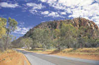
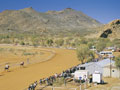
Ruby
Gap Nature Park from the East MacDonnell Ranges
in Northern Territory, Central
Australia
A tourist selfdrive tourist guide and travel information
|
|
|
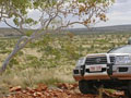
An drive through the East MacDonnell Ranges from Alice
Springs to Ruby Gap.
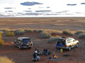
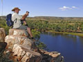
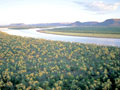
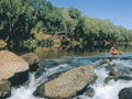
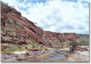 Ruby
Gap Nature Park from the East MacDonnell Ranges - Drive
east to Ruby Gap Nature Park and camp on the banks of
the Hale River. Ruby
Gap Nature Park from the East MacDonnell Ranges - Drive
east to Ruby Gap Nature Park and camp on the banks of
the Hale River.
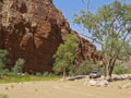
Although just 38
kms from Arltunga, the drive is slow going and may
take up to 2.5 hours.
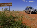
Situated 150km east of Alice Springs, access
to Ruby Gap is via the Arltunga Historical Reserve.
A high clearance 4WD is essential. Heavy rains may
cause the roads to become temporarily impassable.
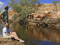
From the park entrance there is a 5km drive along the
river bed and then a 2km walk to reach Glen Annie Gorge.
 The
park is generally accessible all year round, however
the cooler months, from April to September, are more
pleasant. The
park is generally accessible all year round, however
the cooler months, from April to September, are more
pleasant.
There are several camp grounds in this Park, however,
there are no other facilities available.
Camping Permitted
There are no facilities available, but camping is permitted
along the river between the park entrance and Glen Annie
Gorge. Camping fees apply and can be deposited in the
honesty box at the park entrance.
The Park protects one of the few remaining healthy
populations of the Brush-tailed Possum, which is declining
in Central Australia.
If
going to Ruby Gap suggest you click here for the Governemnet
Fact sheet.
|
|
|
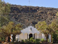
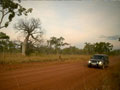
How to Get to Arltunga
Located 110km east of Alice Springs, the Reserve can
be easily reached in 2WD vehicles. After 70km of sealed
road along the Ross Highway there is a formed gravel
road which leads north east for 33km to Arltunga. (Note:
gravel road surface conditions do vary and roads may
be impassable when wet).
Arltunga Historical Reserve Office
Ph: (08) 8956 9770.
Regional Office - Arid Zone Research
|
 |
|
|
10 Day Selfdrive Route
Binns Track Selfdrive Route, Mt Dare to Alice
Springs and finish Timber Creek
Then travel to Darwin in the Top End
Northern Territory in Australia
|
|
Access: 4WD - 4X4 - Four Wheel
Drive (Seasonal access only)
Start: From Mt Dare
Lenght of Track: 2191km
Finish: Timber Creek
Highlights: Mount Dare, Finke
River, Mac Clark Conservation Reserve, NDhala
Gorge, Arltunga Historical Reserve, Pinnacles
Track, Davenport Ranges, Territorys heart of
gold, Tennant Creek, Devils Marbles, Aboriginal
musicians at Winanjjikari Music Centre, Threeways
Roadhouse, Lake Mary Ann, Dunmarra, Humbert River
Track, Bullita Homestead, Drover's Memorial Park,
Timber Creek, Gregory's Tree on the banks of the
Victoria River.
|
 |
Day 1: Mt Dare to Alice Springs
Watch sunrise at Mount Dare in South Australia
and set off early for the 421 kms journey along
Old Andado Track to Alice Springs in the Northern
Territory. Flanking the western fringe of the
Simpson Desert, the track passes sand ridges five
to eight metres high and meanders through the
Finke River flood-out. Enjoy a picnic lunch at
Molly Clarks Old Andado Homestead and unwind
in its old-world charm.
Then, travel a further 40 kms to the Mac Clark
Conservation Reserve and explore its acres of
rare Acacia Peuce trees, found in only two other
locations in the world. Continue your journey
northbound via Santa Teresa, an Aboriginal community
renowned for its vibrant artworks.
By appointment only, from Monday to Thursday,
you can watch artists tell their stories on canvas.
Drive to Anzac Hill in Alice Springs and watch
the sun descend beyond the MacDonnell Ranges.
Camp, backpack or stay overnight in the towns
many accommodation options.
|
 |
 |
|

|
Day 2: Alice Springs to Ruby Gap
Drive to NDhala Gorge via Numery Road, where
more than 6000 ancient rock carvings, known as
petroglyphs, trace the Arrente Aboriginal history
of the land. The 97 kms route crosses the Ross
River several times and is impassable after heavy
rain. Then, relive the heyday of Central Australias
1980s gold rush fever at Arltunga Historical Reserve.
Located 51 kms from the gorge, here you can
explore the mine ruins, pan for gold and cook
a barbeque lunch. Camp overnight at the Arltunga
Bush Hotel or drive east to Ruby Gap Nature Park
and camp on the banks of the Hale River. Although
just 38 kms from Arltunga, the drive is slow going
and may take up to 2.5 hours.
|
|
 |
Day 3: Ruby Gap to Gemtree
The adventure picks up pace along the Pinnacles
Track, which connects Gardens Road to the Plenty
Highway and offers breathtaking views of the rugged
Harts Ranges.
Travel 6 kms west along the highway to Gemtree
Caravan Park your campsite for the evening
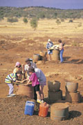
and fossick for semi-precious stones in the creek
beds of Gemtree and Mud Tank.
Here, garnets and zircons are usually found only
a few centimetres below the surface. This is a
95 kms drive from Arltunga Historical Reserve.
|
 |
 |
Day 4: Gemtree to Davenport
Ranges
This section of the track is predominantly off-road
and travels through several outback cattle stations
to link to the Davenport Ranges the boundary
between the traditional lands of the Warumungu,
Alyawarre and Kaytetye Aboriginal people. Wake
early and drive 94 kms east along the Plenty Highway.
Gemtree to Davenport Ranges This section of the
track is predominantly off-road and travels through
several outback cattle stations to link to the
Davenport Ranges the boundary between the traditional
lands of the Warumungu, Alyawarre and Kaytetye
Aboriginal people. Wake early and drive 94 kms
east along the Plenty Highway.
Here, the track travels along 100 kms of station
farm roads, which surround the Ampilatwatji and
Elkedra communities. The Binns Track intersects
the Davenport Murchinson Road 14 kms south east
of Murray Downs in the Davenport Ranges. Drive
north to Old Police Station Waterhole via Hatches
Creek and the Frew River Loop, an alternative
to the main access road.
|
 |
 |
 |
 |
Day 5: Davenport Ranges to Devils Marbles
Explore the quiet and understated beauty of the
Davenports on one of the many walking tracks within
the park. Then, load the four-wheel- drive and
continue along the Frew River Loop to the main
access road. This is a 9 kms journey that will
take one hour to complete. Follow the main access
road to Epenarra and drive 81 kms west to Whistleduck
Creek.
Like Old Police Station Waterhole, this is an
ideal place to relax. After your vigour is restored,
the track continues 90 kms west to incept the
Stuart Highway just north of the Devils Marbles.
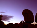
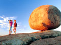
Drive south to this cultural wonder and explore
the precariously placed boulders that sit atop
one another. Later, set up camp at the Devils
Marbles Conservation Reserve and watch the sun
set behind these massive terracotta icons.
|
 |
 |
Day 6: Devils Marbles
to Tennant Creek
Keen photographers should wake early to capture
the marbles illuminated in soft beams of honey-coloured
light. After, drive approximately 90 kms north
to the Territorys heart of gold, Tennant Creek.
Strike a beat with local Aboriginal musicians
at Winanjjikari Music Centre. Spearheaded by Jeff
OLaughlin, who has previously worked with the
Red Hot Chilli Peppers and the Corrs, visitors
are encouraged to join a jam.
The centre is open Monday to Thursday, 8-12am.
In the afternoon, visit Nyinkka Nyunyu Art and
Culture Centre to learn more about the Warumungu
peoples connection to the land. Immerse yourself
in their story and vibrant artwork, before enjoying
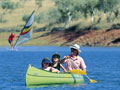
a barbeque lunch and cool swim at Lake Mary Ann.
Choose to camp, backpack or stay overnight in
accommodation within the town.
|
 |
 |
Day 7: Tennant Creek to Dunmarra
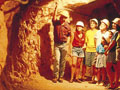
Set off early for an underground experience at
the Battery Hill Mining Centre a tribute to
Tennant Creeks gold rush era. Pan for gold and
explore various artefacts from the 1930s. Then,
drive to the Pink Palace on the northern fringe
of town and watch the Julalikari women paint their
stories onto canvas.
Enjoy a cold drink and bite to eat at the family
run Threeways Roadhouse, located 25 kms north
of Tennant Creek on the Stuart Highway. Continue
your journey north to Newcastle Waters, 255 kms
from Threeways. Now a deserted ghost town, after
rain its inhabited by large flocks of water birds.
Travellers can stretch their legs and explore
the remains of the 1960s Junction Hotel, museum
and the Drover's Memorial Park. Travel a further
78 kms north to Dunmarra and pull in to the Wayside
Inn - your campsite for the evening. On weekends
during the dry season, the Inn serves mouth-watering
spit fire roasts for dinner and hosts snake demonstrations.
|
 |
 |
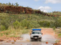
Day 8: Dunmarra to Humbert River Track
Load the four-wheel-drive and set of on a 290
kms journey to the Victoria River Downs one
of the largest cattle stations in the Territory.
Here, you can get your heart pumping on a scenic
chopper flight over Nitmiluk and Kakadu National
Parks. Continue 55 kms west along the highway
to the Humbert River Ranger Station via Yarralin.
Fuel and basic supplies are available at this
small Aboriginal community if required.
Lock the hubs and engage four-wheel-drive to
tackle the Humbert River Track at the entrance
of Gregory National Park. Originally a packhorse
trail that connected Bullita Homestead to the
Humbert River, the track is slow going in sections
with several river crossings and jump-ups. Set
up camp at the Top Humbert Yard site, just north
of the Wickham Track turnoff.
|
 |
 |
Day 9: Humbert River Track to Bullita
Homestead
The northern section of the Humbert Track is
jam packed with more four-wheel driving thrills
en route to Bullita Homestead. Slow going in sections,
it can take up to 4 hours to complete this 48
kms drive. Located on the banks of the East Baines
River, the quaint homestead is a reminder of Gregory
National Parks pastoral history.
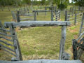
Wander through the original timber stockyards
- believed to be one of the oldest in the Territory
- and get lost in the stories of yesteryear that
don the homestead walls. Stay overnight at Bullita
Campground and enjoy a night of tall tales by
a campfire.
|
 |
 |
Day 10: Bullita Homestead to Timber Creek
Make the most of your last day and wake early
for an adventure at Limestone Gorge a picture
perfect swimming hole engulfed by soaring gorge
walls. Explore the dolomite and crater formations
in the ravine and cool off, before driving north
to Timber Creek, located on the Victoria Highway.
Once in town, enjoy a cold drink and counter meal
at one of the local pubs.
Later, visit Gregory's Tree on the banks of the
Victoria River - an old boab tree that is inscribed
with the arrival and departure dates of explorer
Augustus Gregory and his party in 1855. Keen anglers
should wet their line in the Victoria River and
prepare for a battle against the almighty barramundi,
while art lovers should visit the rock art paintings
at Joe Creek picnic area, east of Timber Creek
on the Victoria Highway. Camp or stay in accommodation
overnight.
|
 |
|
|
|
|
|
|
|
|
|
Find a self drive 4wd hire, camper,
motorhome or camper rental from Alice Springs
to Uluru and return or oneway to Darwin via
Kakadu and Litchfield.
See our specials at Australia
4wd Rentals or email
and ask us. Minimum rental is 5 days. Ask
us how to reserve a vehicle for only AUD $100
up to 9 months from travel.


|
|
|
Photographs Courtesy Of: NTTC
- Northern Territory Tourism Commission.
Maps Courtesy Of: NTTC - Northern Territory
Tourism Commission.
Photographs Courtesy Of: PJ B &
M Hutchinson Private Collections
Information courtesy of Parks and Wildlife Service NT
for the promotion of tourism for the Larapinta Trail.
Photographs
Courtesy of NTTC - Northern Territory
Tourism Commission
Information
courtesy of Parks Northern Territory
The Goholi
Our Mission Statement
As one of Australia's largest licensed
Travel Agents Goholi is dedicated to campervan and motorhome
hire and rentals. We will source the different options
for you. We will look at all the extras and find the
best vehicle package for you or even a multiple option
for you to choose from. With our head Office in the
heartland of the Top End of Darwin we can advise you
of the current situations of Uluru Kata Tjuta National
Park - Ayers Rock, Watarrka National Park, West MacDonnell
Ranges, East MacDonnell Ranges, Kakadu National Park,
Uluru (Ayers Rock), Gibb River Road Western Australia
and the - Erldunda - Kulgera - Oodnadatta Track - Coober
Pedy (Opal field) - Woomera - Port Augusta areas.
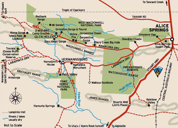
East MacDonnell National Park
and West MacDonnell National Park
in the MacDonnell Ranges in Northern Territory, Central
Australia
A tourist selfdrive tourist guide and travel information
East MacDonnell National Park
and West MacDonnell National Park in Central Australia
West
MacDonnell Map West
MacDonnell National Park East
MacDonnell National-Park
East
MacDonnell Map
West MacDonnell National Park
and surrounding areas
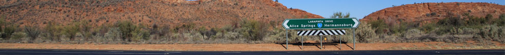
Larapinta
Trail Glen
Helen Gorge Glen
Helen Lodge accommodation Ellery
Creek Big Hole Ochre
Pits Ormiston
Gorge Redbank
Gorge Waterhole Roma
Gorge Serpentine
Chalet Serpentine
Gorge Simpsons
Gap Standley
Chasm
Honeymoon
Gap Palm
Valley
Albert
Namatjiras Monument
Namatjira
Drive Namatjira
Twin Gums Hermannsburg
Ghost
Gum Wallace
Rockhole Palm
Valley
East MacDonnell National Park
and surrounding areas
Arltunga
Historical Reserve and hotel or camping Trephina
Gorge Emily
Jessie Gap Corroboree
Rock Ross
River Resort Ruby
Gap N'Dhala
Gorge Nature Reserve Gemtree
Chambers
Pillar Rainbow
Valley
Other Highways, Scenic Routes,
Ways, offroad 4wd Tracks and Roads in Central Australia
The
Mereenie Loop Red
Centre Way Explorers
Way Stuart
Highway Ernest
Giles Road Namatjira
Drive Larapinta
Drive Luritja
Road Lasseter
Highway Binns
Track
Top End - Natures Way in Northern
Territory Australia
Darwin
Tropical
Darwin Map
of Northern Territory Katherine
Gorge Tennant
Creek Devils
Marbles Kakadu
National Park Natures
Way Top End Katherine
Gorge Litchfield
National Park
Alice Springs and Uluru and on
the way
Alice
Springs Alice
Springs Airport The
Ghan Alice Springs Alice
Springs Heavitree Gap Uluru
Kata Tjuta National Park
Uluru
Ayers Rock Ayers
Rock Resort at Yulara Voyages
Resort at Ayers Rock Resort, Yulara Ayers
Rock Airport 'Connellan Airport' Kata
Tjuta 'The Olgas' Sounds
of Silence dinner Mount
Sonder Mount
Connnor Mount
Ebenezer Curtin
Springs Stuarts
Well Erldunda
Kings Canyon
Watarrka
National Park Kings
Canyon Kings
Creek Station Kings
Canyon Resort Glen
Helen Lodge accommodation
Remote access sites
Henbury
Meteorites Conservation Reserve Gosse
Bluff Tnorala Tylers Pass Haasts
Bluff - lkuntji
Alice Springs camper hire and
Alice Springs motorhome rentals return and one way
Alice
Springs campervan hire and camper rentals
Alice Springs
motorhome hire and RV rentals
Alice Springs 4wd hire | Alice
Springs 4 wheel drive rentals | Alice Springs 4X4 hire
4WD Hire
from Alice Springs with oneways to Darwin
Uluru guided camping tours and
Kakadu guided camping safaris
Across Australia
Adventure Tours at http://www.australia4tours.com/
Uluru
Northern Territory www.uluruadventuretours.com
Kakadu
Northern Territory adventure tours and safaris at www.kakaduadventuretours.com
Way outback
Ayers Rock adventure tours and safaris at www.ulurusafaris.com
Way outback
Kakadu and Litchfield adventure tours and safaris at
www.kakadusafaris.com
Instant availability
on Kakadu and Top End one day tours www.kakaduholidays.com/
Instant
availability on Darwin one day tours www.darwin4tours.com/
Search, find and about West
MacDonnell National Park and East MacDonnell National
Park the MacDonnell Ranges in Central Australia a resource
travel guide.
|
|
|