|
Coober Pedy Antakarinja country
The Opal Coober Pedys passion In 1915, the New
Colorado Gold Prospecting Syndicate, consisting of a
Mr. Jim Hutchison, his 14 year old son William, a Mr.
Winch and a Mr. McKenzie had been unsuccessfully prospecting
for gold out here in the middle of South Australia.
The young lad, Willie had been left in camp to look
after their supplies but disobeyed orders and wandered
off to search for water around the foothills of a nearby
range. There was a degree of apprehension among the
men when he failed to turn up after dark. But a short
time later, he strode into camp with a grin on his face.
Over his shoulder was slung a sugar bag full of opal.
Now this was a very fortuitous find for the young William
not only did he come across the opal, but he also
discovered something equally as precious out here
a supply of good fresh water. This was on the 1st February
1915 - 8 days later, they pegged the first opal claim.
The catalyst for Coober Pedys existence had been discovered.
Word of the find spread quickly and by the middle of
1916, miners had moved to the area. Young Willie did
not live long enough to see the fruits of his discovery.
He drowned five years later while driving cattle across
the Georgina River, on the Birdsville Track. Construction
workers from the trans continental railway, followed
by soldiers returning from World War 1 came to the opal
fields. They introduced a unique method of living underground
in "dugouts". Its claimed these soldiers, come miners,
were used to digging and living in trenches, they knew
the advantages to be found in the even cool temperatures
of the dugout. Given Coober Pedy is one of the hottest
places on earth to live, it only seemed logical. Several
major discoveries continued to be made, so in 1920 the
local Progress Committee decided that the field should
have a proper name.
After much deliberation the choice fell on Coober Pedy.
The most widely accepted translation is thought to be
the Aboriginal words Kupa Piti which loosely means White
Man in water hole. Water Coober Pedys problem Id
suggest that many of the miners wished they were in
a water hole. Lack of water, which often had to be re-used
many times before being discarded, was always a problem
in Coober Pedy. Water and provisions had to be trucked
in great distances, under incredibly difficult conditions.
The water problem became so bad that in 1924 the Government
decided to build a 2,000,000 litre steel water tank
to catch a bit of rainfall runoff. The only problem
was, there was no rain until 1925 to put any water in
the tank. The town got a much more reliable supply in
1985. The water supply now comes from an underground
source 24 kilometres north of the town. The treatment
and pumping process make this some of the most expensive
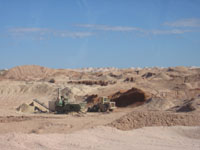
town water in the world. Field of dreams The 1950s miners
began experimenting with the open cut method of mining
and then in the 60s, all mines became increasingly more
mechanised, with blowers and trucks, conveyer belts
shafts that got deeper down to about the 30m level.
Interestingly large companies have never operated in
the area. Mainly due to the fact that a miner can only
take out a lease of 50 square metres and then theyre
obliged to operate for 20 hours a week. Some argue that
this has slowed progress in the town.
Development has come a distant second to the need
to find opal. The Dog Fence But in amongst the mines
and the mullock heaps, runs one of the lesser known
achievements of the modern age, the longest man made
structure in the world. It was established in 1946 to
keep the Dingo away from the merino. The fence begins
east of Surfer's Paradise in Queensland, and ends up
north of Ceduna in the Great Australian Bite. Back in
1989 vast tracks of it were washed away in the floods.
They reckon 20,000 sheep were killed by dingoes while
it was down, which gives you a fair idea what happens
when they do get in. The economic benefit of the fence
far outweigh the disadvantage. Quite frankly - no fence,
no sheep. Being underground During the 1960's, the mining
industry expanded rapidly due to the many European migrants
who came to seek their fortunes. There were over forty
different nationalities in Coober Pedy which created
a few dilemmas. When it was decided to build a church
in the 1960s the idea was to build one church shared
by all.
In true pioneering spirit, everyone pitched in to build
what is believed to be the worlds first underground
church. Opal fever has ensured that Coober Pedy continues
to attract unique characters, all of whom have been
seduced by the glow of a great opal. Various levels
of professionalism are required to find opals. But if
its your time, then the opal gods will shine. And its
that special feeling that a hidden treasure lies just
behind the next layer of rock that keeps bringing people
to Coober Pedy. Its definitely an Australian icon town
and its all about the opals.
Courtesy of: SA Tourism and SA History
|
 In
the opal mining outpost of Coober Pedy, 4000 residents
from 50 countries have made an art form of all things
quirky. With half the population living in underground
dugouts to escape high temperatures in summer, only
in Coober Pedy will you find an underground church,
underground hotels and a golf course without a blade
of grass.
In
the opal mining outpost of Coober Pedy, 4000 residents
from 50 countries have made an art form of all things
quirky. With half the population living in underground
dugouts to escape high temperatures in summer, only
in Coober Pedy will you find an underground church,
underground hotels and a golf course without a blade
of grass.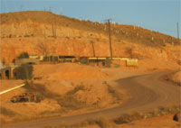 Town
tours feature underground homes and opal mines, an art
gallery and pottery, and there's also a host of awesome
natural landscapes including the Painted Desert, the
Moon Plain and the Breakaways. (Incidentally, these
great desert locations have attracted film makers from
around world, for movies including Fire in the Stone,
Mad Max: Beyond Thunderdome, Ground Zero, Pitch Black
and Val Kilmer's Red Planet.)
Town
tours feature underground homes and opal mines, an art
gallery and pottery, and there's also a host of awesome
natural landscapes including the Painted Desert, the
Moon Plain and the Breakaways. (Incidentally, these
great desert locations have attracted film makers from
around world, for movies including Fire in the Stone,
Mad Max: Beyond Thunderdome, Ground Zero, Pitch Black
and Val Kilmer's Red Planet.) 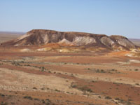 Taking
its name from the Aboriginal word "kupa" (uninitiated
man or white man) and "piti" (hole), Coober Pedy produces
most of the world's opals. Its opal fields, discovered
in 1913 by 14-year-old Willie Hutchison, cover an area
of 4,954 square kilometres and consist of 70 individual
fields. You can try your luck at "noodling" (fossicking)
at various spots around town; get a great insight into
the history of Coober Pedy at the Old Timers Mine and
Museum; and buy up big at more than 30 shops.
Taking
its name from the Aboriginal word "kupa" (uninitiated
man or white man) and "piti" (hole), Coober Pedy produces
most of the world's opals. Its opal fields, discovered
in 1913 by 14-year-old Willie Hutchison, cover an area
of 4,954 square kilometres and consist of 70 individual
fields. You can try your luck at "noodling" (fossicking)
at various spots around town; get a great insight into
the history of Coober Pedy at the Old Timers Mine and
Museum; and buy up big at more than 30 shops. 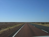 You
can tag along with the famous Outback Mail Run to Oodnadatta
and William Creek, or join the nightly Star Gazing Tour
on the Moon Plain. Visit over Easter for the annual
Coober Pedy Opal Festival (featuring events from the
fun to the outrageous), or in October for the Coober
Pedy Races.
You
can tag along with the famous Outback Mail Run to Oodnadatta
and William Creek, or join the nightly Star Gazing Tour
on the Moon Plain. Visit over Easter for the annual
Coober Pedy Opal Festival (featuring events from the
fun to the outrageous), or in October for the Coober
Pedy Races. 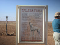 70
km round trip from Coober Pedy will take you through
the Breakaways, to the famous dog fence and the Moon
Plains the local nickname for the moon-like desert
landscape along the fence. The two-metre high dog fence
stretches across three states for more than 5,300 km
in an effort to keep northern dingoes away from southern
sheep and is the longest fence in the world. Check with
the authorities the track conditions before going though.
70
km round trip from Coober Pedy will take you through
the Breakaways, to the famous dog fence and the Moon
Plains the local nickname for the moon-like desert
landscape along the fence. The two-metre high dog fence
stretches across three states for more than 5,300 km
in an effort to keep northern dingoes away from southern
sheep and is the longest fence in the world. Check with
the authorities the track conditions before going though.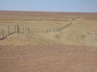 Need
a Caravan Park:
Need
a Caravan Park: